Google Maps Renames Lake Ontario to Lake America for US Users Following Executive Order
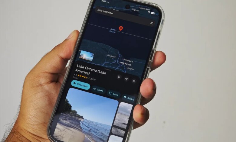
Users opening Google Maps within the United States may notice a major cartographic change on their screens: Lake Ontario, one of the five Great Lakes of North America, is now labeled as “Lake America.” The modification follows a formal update by the U.S. Geographic Names Information System, which officially altered the domestic designation of the body of water after an executive order issued by President Donald Trump. In response, Google updated its mapping interface to align with official federal records, triggering a localized shift in how the geographic feature is displayed to millions of digital map users.
The change does not apply universally across the globe. Because Lake Ontario forms a natural international boundary between the United States and Canada, the cartographic adjustment has highlighted the complex mechanisms tech platforms use to manage cross-border geographical features. While users accessing the platform from within U.S. borders see Lake America, users located in Canada continue to see the traditional designation, Lake Ontario. For the remainder of the global audience accessing Google Maps outside these two nations, the service presents a combined label displaying both designations simultaneously.
How Location-Based Labeling Alters the Mapping Experience
For decades, physical paper atlases provided a singular, standardized view of international geography. Modern digital map platforms, however, rely on dynamic location tracking to tailor geographical names according to local laws, sovereign claims, and official government databases. Google’s long-standing corporate policy dictates that its mapping software reflects the official geographic designations established by local government authorities within their respective jurisdictions.
When two sovereign nations share a geographical landmark but recognize different official names for it, the mapping software adapts by rendering different versions of the map based on the IP address or geolocation of the device viewing it. In this case, the U.S. government’s administrative decision changes the internal map view for domestic users without altering how Canadian authorities or international entities classify the lake.
| User Location | Label Displayed on Google Maps | Underlying Administrative Basis |
|---|---|---|
| United States | Lake America | U.S. Geographic Names Information System update following presidential executive order |
| Canada | Lake Ontario | Official Canadian government naming standards and geographic databases |
| Rest of the World | Lake Ontario (Lake America) | Google platform policy for disputed or dual-designated international features |
This localized presentation strategy allows digital mapping providers to remain compliant with domestic regulatory standards in individual countries while avoiding direct intervention in international naming disputes. However, it also creates a situation where two individuals looking at the exact same physical body of water on the same application will see entirely different names depending entirely on which side of the international border they reside.
The Precedent Set by the Gulf of Mexico
The renaming of Lake Ontario within domestic U.S. digital maps is not an isolated incident. A direct technical and administrative precedent occurred in early 2025, when the U.S. government altered its official domestic naming records to designate the Gulf of Mexico as the “Gulf of America.” Following that administrative update, Google implemented the exact same localized labeling rules: users in the United States were presented with the name Gulf of America, Mexican users retained the historic Gulf of Mexico labeling, and users in third-party countries were shown a dual-labeled map listing both names.
The repeated application of this framework demonstrates how tech platforms handle administrative border shifts. Rather than establishing an independent editorial board to determine correct cartographic terminology, major navigation services rely on automated or semi-automated compliance with federal gazetteers and regional databases. When a sovereign government updates its federal geographic database, mapping services update their primary regional views accordingly to prevent regulatory friction and maintain regional compliance.
Sovereignty, Borders, and the Reality of Shared Geography
The practical significance of this naming change lies in the shared nature of the lake itself. Unlike landlocked bodies of water contained entirely within a single nation’s borders, Lake Ontario contains thousands of square miles of Canadian territorial waters, with extensive shorelines running along the province of Ontario. The unilateral administrative decision by the U.S. government to update its internal naming registry does not carry legal force over Canadian territory, nor does it override internationally recognized maritime boundaries.
This reality forces navigation providers to separate domestic administrative declarations from international consensus. For affected organizations, logistics providers, maritime operators, and casual travelers, the dual-naming system creates a fragmented digital environment. A user navigating from New York toward the Canadian border will experience a shift in context depending on how software handles border crossings, data caching, and regional network requests.
The broader implication of dynamic map localization extends beyond a single body of water. As governments increasingly use executive actions and administrative updates to assert symbolic or geographical changes, digital platforms will face growing technical challenges in maintaining consistent spatial data. While localized map displays solve legal compliance requirements for technology companies, they also introduce a fractured perception of global geography, where shared natural features no longer possess a single, universally recognized name on public screens.
What Lies Ahead for Digital Cartography
As Google Maps continues to roll out the updated labeling for Lake America across domestic U.S. platforms, public adaptation will take time. The change highlights how thoroughly software algorithms and administrative policy govern modern spatial awareness. Traditional geography once relied on printed records that changed slowly over decades; today, a single domestic administrative decree can alter the maps on millions of smartphones overnight.
What remains uncertain is how other commercial mapping services, global navigation systems, and educational databases will respond to the U.S. Geographic Names Information System change. While Google has reaffirmed its standard policy of mirroring official government databases, other international platforms may choose different approaches to handling dual-designated international border waters. For now, travelers crossing between the U.S. and Canada will see geography change in real time on their devices, reflecting a digital landscape as dynamic as the policies behind it.