Google Maps Updates Lake Ontario to ‘Lake America’ in the US Following Executive Order: What the Regional Name Change Means
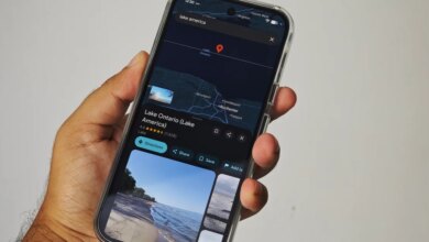
Digital cartography has once again intersected with international politics as Google Maps begins updating its labeling of Lake Ontario for users within the United States. Following an executive order issued by U.S. President Donald Trump, the shared body of water is now designated as “Lake America” when accessed from inside U.S. borders. However, the change is strictly localized: viewers in Canada will continue to see the historical name, while international users outside both nations will encounter a dual-labeled map.
The development highlights the complex mechanisms through which private technology companies navigate conflicting geopolitical mandates, national borders, and established cartographic standards. Coming amid broader trade tariff disputes between Washington and Ottawa, the unilateral renaming has sparked pushback from Canadian officials, resistance from state leaders within the U.S., and renewed debate over how digital platforms should handle politically contested geographical terminology.
How the Digital Renaming Works Across International Borders
Unlike traditional paper maps, modern digital mapping services operate under dynamic localization algorithms. Google confirmed that its display logic for the newly designated body of water depends entirely on the geographical location of the user accessing the service:
- Inside the United States: Users will see the body of water labeled as “Lake America.”
- Inside Canada: Users will continue to see the traditional designation, “Lake Ontario.”
- Rest of the World: Users viewing the map from outside both the U.S. and Canada will see both names displayed simultaneously.
According to Google, this implementation aligns with its longstanding global policy for managing bodies of water whose official names differ by international jurisdiction. When sovereign nations maintain conflicting designations for shared geographic features, digital map providers typically render labels based on the user’s localized IP address or regional settings, satisfying domestic legal requirements while preserving existing designations abroad.
Google’s stance reflects its reliance on formal administrative sources. In the United States, tech companies follow the standards established by the U.S. Board on Geographic Names, an arm of the United States Geological Survey (USGS). When an executive order alters federal geographic records, platforms that index official U.S. government datasets automatically update their primary labels for domestic viewers to maintain compliance with federal naming conventions.
Political Resistance and Local Backlash
The political significance of the order has drawn immediate reactions across federal, state, and international lines. The decision unfolds against a backdrop of escalating trade tariff tensions between the U.S. and Canada, prompting swift symbolic and administrative responses across the border.
In Canada, authorities responded to the administrative change by erecting a prominent new physical sign along the shoreline, declaring the body of water “Lake Ontario. Now and Always.” The statement underscores Ottawa’s refusal to recognize the U.S. presidential order as having any legal or geographic validity over Canadian territory or international waters.
Disagreement over the label is not confined to the international border; notable domestic friction has also emerged within the United States. New York State Governor Kathy Hochul publicly rejected the federal renaming on social media, writing that “New York won’t be calling it that.” Because state agencies, local municipalities, and regional transportation authorities often manage their own official signage and documentation, state-level non-compliance could create an operational disconnect between federal digital mapping tools and local physical infrastructure across Upstate New York.
Public reaction across online forums and social platforms has also reflected skepticism, with critics pointing out the logistical confusion caused by altering established place names. At the same time, policy analysts note that mapping services are legally bound to reflect official government databases regardless of public sentiment or local state opposition.
Historical Roots Versus Modern Executive Actions
The naming of Lake Ontario carries centuries of historical and indigenous heritage. The word “Ontario” derives from the Iroquoian terms Kaniatarí:io or Oniatarí:io, historically translated as “lake of shining waters” or “beautiful lake.” The designation has been continuously documented on maps and in legal records since at least the 17th century, serving as a shared geographical identifier for indigenous populations, French and British colonial administrations, and modern sovereign states alike.
The decision to supplant an indigenous and historically established name via executive decree represents a major shift in how geographic nomenclature is applied to shared border infrastructure. The practical significance lies in the potential for cartographic fragmentation: when physical geography is subjected to unilateral political shifts, digital systems must create fragmented versions of reality to remain compliant with local regulations.
This is not the first instance of executive intervention altering digital maps in the U.S. Approximately 18 months prior to the Lake Ontario decision, a similar presidential mandate targeted the Gulf of Mexico, prompting similar algorithmic adjustments on tech platforms operating within U.S. borders. Taken together, these measures signal an increasing use of geographical naming as a tool of political and diplomatic leverage.
Platform Consistency and the Role of Competitors
While Google Maps has already begun rolling out the update, competing digital navigation systems are expected to follow a similar trajectory. Apple Maps has not yet implemented the change across its interface, but industry standards suggest that major platforms will eventually comply with the updated designations recorded by the U.S. Board on Geographic Names.
For multinational software providers, maintaining separate cartographic layers for different countries introduces unique operational challenges. Key considerations for mapping platforms include:
- Regulatory Compliance: Meeting local legal standards in every operating market to prevent regulatory penalties or operational restrictions.
- User Navigation: Ensuring that search functionality functions properly whether a user queries “Lake Ontario” or “Lake America.”
- Cross-Border Logistics: Preventing confusion for commercial transport, maritime shipping, and international aviation routing that rely on consistent spatial data.
Because navigation engines must reconcile localized political naming with global database integrity, search algorithms are typically configured to recognize both historical and updated terms as synonyms in back-end queries, even when the visual display reflects local political directives.
The Broader Implications for Global Cartography
The dispute over Lake Ontario underscores a growing challenge in the digital age: physical geography is immutable, but digital representations of geography are flexible, dynamic, and vulnerable to geopolitical policy changes. As digital maps become the primary medium through which people navigate physical space, technology companies find themselves acting as cartographic arbiters between conflicting national claims.
For residents, businesses, and travelers in the Great Lakes region, the immediate practical impact will be a divided digital experience depending on which side of the border a device connects from. While U.S.-based devices will render the new “Lake America” label on federal datasets and primary map views, local state opposition in New York and firm resistance from Canadian authorities ensure that “Lake Ontario” will remain the dominant everyday designation in physical signage, regional commerce, and international diplomacy.